
Multi-use pathways, flashing lights & more: What’s new & what’s coming to Chilliwack roads
Everyone needs to get around and everyone has an opinion on what should be improved where and when – here's a spring update on some of it
Beyond sports and politics, few topics prompt water-cooler banter more than the weather and the commute. Driving, cycling, and walking around a city that is growing as fast as Chilliwack and as uniquely laid out as Chilliwack can be a weird and wild adventure.
So what’s happening right now? What has the City of Chilliwack done to fix things? What’s next?
Every month, the City of Chilliwack sends out a list of updates in an email transportation newsletter (I'm signed up, jealous?) giving a brief overview of prominent projects with a link to most of what’s new, what’s underway, and what’s coming.
Here are some highlights from the latest update by city hall, ICYMI:
Downtown
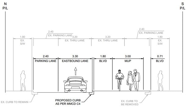
Princess Avenue Active Transportation Project
City staff have been working with McElhanney Engineering on the "Downtown Active Transportation Designs" that will link the Valley Rail Trail with the Downtown core with a protected multi-use pathway network.
(First up, what's the Valley Rail Trail you say? Click the link in the name there to see a map on the city's site. It's the trail that for much of its length follows the old Southern Rail line from Hocking Road to the north, across Highway 1 on the rail bridge, down into Sardis. But it's a broader path system to go further north but already continuing all the way to the Rotary Trail, for one long stretch is really just Wiltshire Road in Sardis.)
Princess Avenue from Mary Street to Young Road forms part of the path system, but the corridor is too narrow to accommodate a trail, according to city hall. So, the city is proposing to convert the corridor to one-way eastbound to keep parking on at least one side of the road.
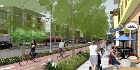

City of Chilliwack renderings, map.
A traffic study has been completed to review the traffic flow and impacts to adjacent signalized intersections and concluded that there would be minimal impacts. Council has supported the recommendation to move forward with consultation of the Downtown Business Improvement Association, businesses and property owners on Princess Avenue between Mary Street and Young Road regarding this conversion to allow for the construction of a protected multi-use pathway.
Anticipated works include:
• Conversion of Princess Avenue between Mary Street and Young Road from two-way traffic to one-way traffic eastbound.
• Construction of a 3m wide protected multi-use pathway.
• Construction of tree-lined landscape boulevard areas on the south side of the road.
• Changes to on-street parking.
Parking you say?
Downtown Transportation and Parking Study
Anyone who comes downtown has witnessed the incredible transformation at District 1881 and in many surrounding areas, all of which is driving a need for more parking. As a result, the city is in the process of completing a downtown transportation and parking study.
Phase 1 of the survey is complete and you're like me and you love pie charts, you're going to love it. There are so many. The project team has considered the feedback received, used it to identify common themes and prepared an engagement summary. Click here to read the full "What We Heard" report.
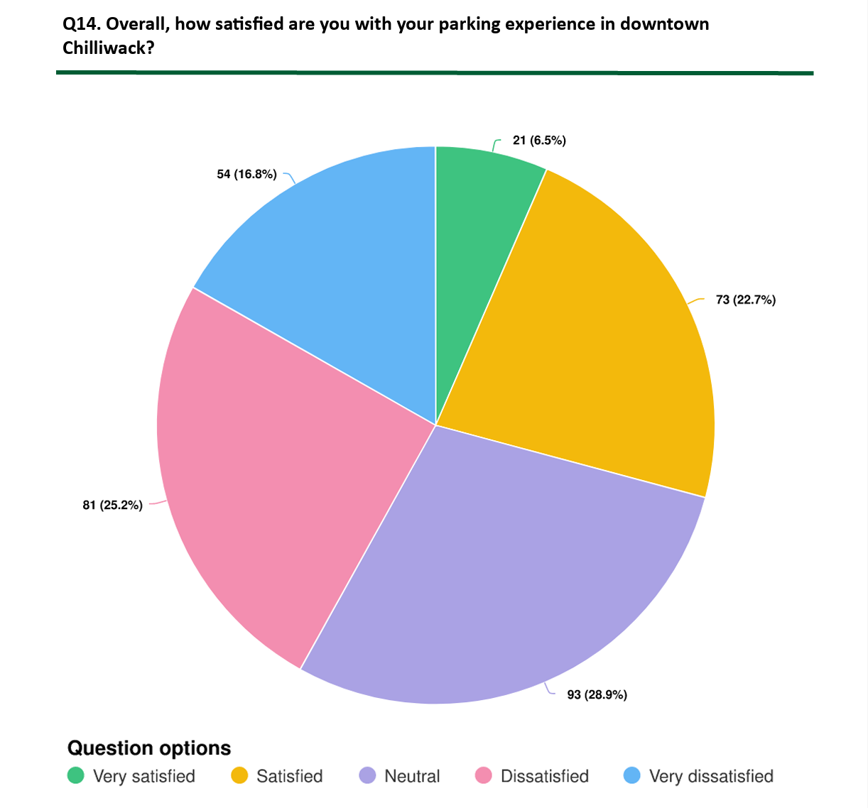
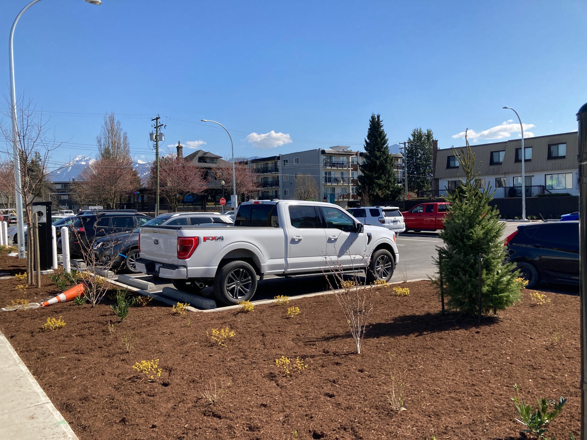
One of many sexy pie charts from the city's downtown parking engagement plan, and a new lot at Princess and Bole. (City of Chilliwack image, photo)
Getting wider & rounder
Prest Road Roundabout and Road Widening
Promontory residents are well aware of the painfully crappy stretch of Prest Road north of the roundabout at Bailey up to McGuire. Yes, it's getting fixed and widened.
Where's it at? A timeline:
• Fall 2025: Archeological Field Investigation completed.
• Winter 2025/2026: Hydro and Telus utility pole relocations completed.
• Summer 2026: Road construction begins.
• Fall 2026: Archeological permitting (tentative).
Due to longer than anticipated delays in receiving the required archeological permit from the Province for necessary field investigation prior to the start of construction, the Prest Road widening will not begin until spring 2026. Once a permit is received, the archeological field investigation (test holes) will go forward under the supervision of the archeologist.
The city will then release the tender for the roadworks based on the shortlist approved by city council this spring. BC Hydro and Telus have relocated their poles in preparation for the road widening and roundabout construction in 2026.
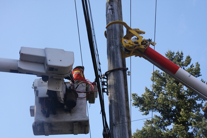
City of Chilliwack image.
Background
The third and final phase of the Prest Road widening project from McGuire Road to Bailey Road began in 2025 with completion in 2026. This phase includes the construction of a roundabout at Prest Road and McGuire Road and road widening between McGuire Road and Bailey Road.
To minimize disruptions, the City completed the culvert replacement at Interception Ditch on Prest Road during the 2024 fish window.
More widening
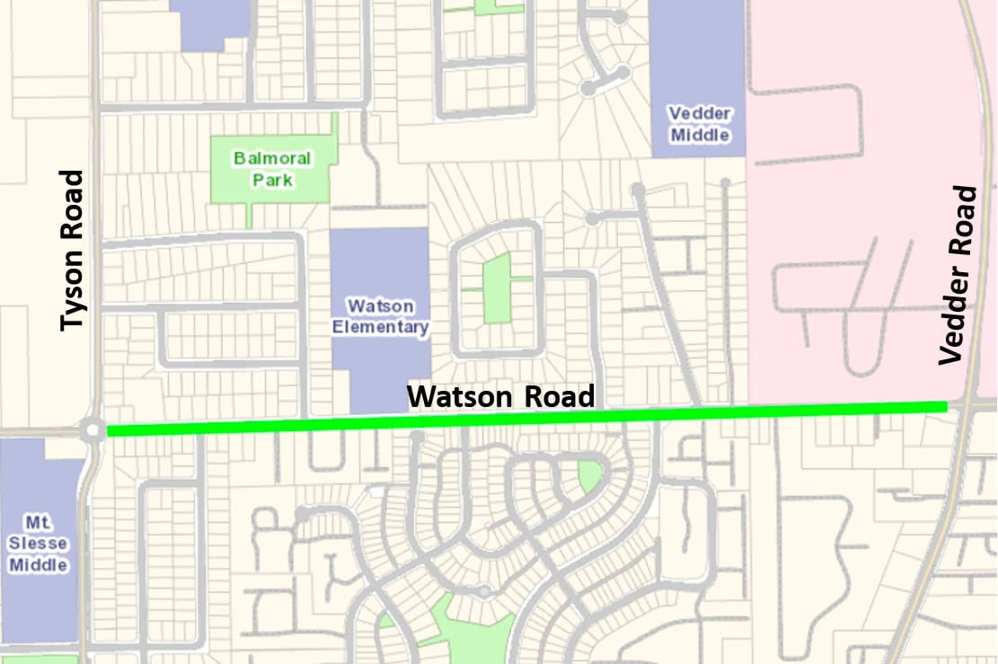
Watson Road - Design-Build Project
Project Details
Watson Road reconstruction and widening will occur from Tyson Road to Vedder Road. The project will provide a safe pathway for active transportation users and improve traffic flow and safety. The project also includes improvements to the sanitary sewer system to help ensure reliable service for everyday needs. Construction is scheduled to begin in early summer.
Work will include:
• Roadway widening to include a new center turning lane.
• Curb, gutter and roadway paving.
• A multi-use pathway on the north side and a sidewalk on the south side of Watson Road. Both will be separated from vehicle traffic with landscaping and street trees.
• Street lighting.
• Drainage and sanitary works.
• Crosswalk and transit stop improvements.
• Signage and road markings.
Timeline
• Construction is scheduled to begin in early summer 2026.
• The project is currently in the procurement process to find a contractor for the design and construction of the project.
Crosswalks
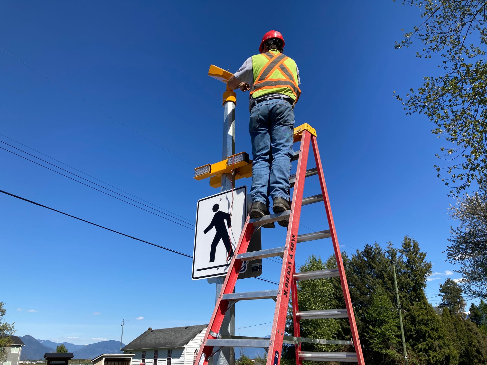
Rectangular Rapid Flashing Beacons
Did you know the City of Chilliwack currently has more than 40 crosswalks enhanced with rectangular rapid flashing beacons (RRFB)?
"Yes, you just told us. But what is a rectangular rapid flashing beacon, Paul?"
Glad you asked. It's hard to explain, but they are put up on crosswalks helping drivers who are idiots actually see that there are people there looking to cross the road so stop, dammit. They are also rectangular shaped lights (beacons) that flash rapidly. If only the name was more explanatory.
The city has dedicated funding each year for the design and construction of three to five RRFB upgrades for existing crosswalks. Crosswalks that would benefit from RRFB upgrades are prioritized based on several factors such as:
|
|
Depending on the location, some installations require more civil works to accommodate the RRFB crossing or to further improve traffic calming measures.
Feedback from pedestrians and motorists are helpful and they are dying to hear from you, so, inquiries about RRFBs can be directed to the engineering department via engineeringinfo@chilliwack.com or 604-793-2907.
New RRFBs
The City's contractor, Crown Contracting, began installing RRFBs at the end of March at the following locations:
• First Avenue at Williams Street
• Reece Avenue at Williams Street
• Tyson Road at Mt. Slesse School
New equipment is being installed at the intersections of First Avenue and Williams Street, and Reece Avenue and Williams Street. The existing pedestrian-controlled traffic signal at Mount Slesse Middle School was converted to an RRFB.
Future Works
Equipment at the intersection of Yale Road and Victor Street, will be installed in June. Work will include lighting improvements at this location and the Yale Road and Fletcher Street crossing.
Another location is being installed as part of the current Knight Road multi-use pathway project.
RRFB designs at four other crosswalks began in September 2025 for the following locations:
• Hope River Road at Kent Road
• Gibson Road at Yale Road
• Menzies Street at Macken Avenue
• Yale Road at the Lickman Park & Ride (works will include the addition of curb bulges for traffic calming and to reduce the crossing on the roadway)
But don't get too excited, the city says installation at these locations will proceed "when funding becomes available."
Knight's new shining armour
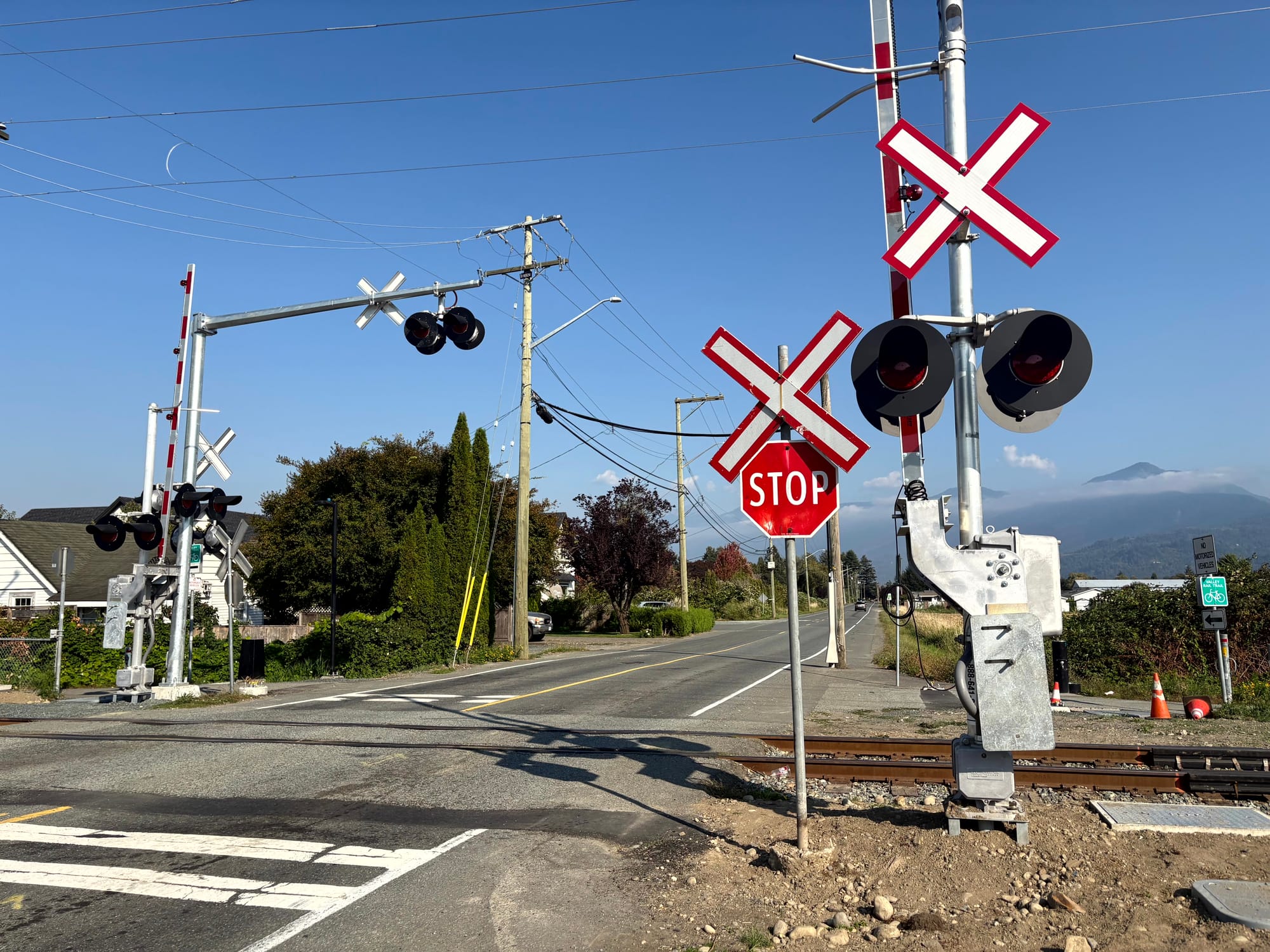
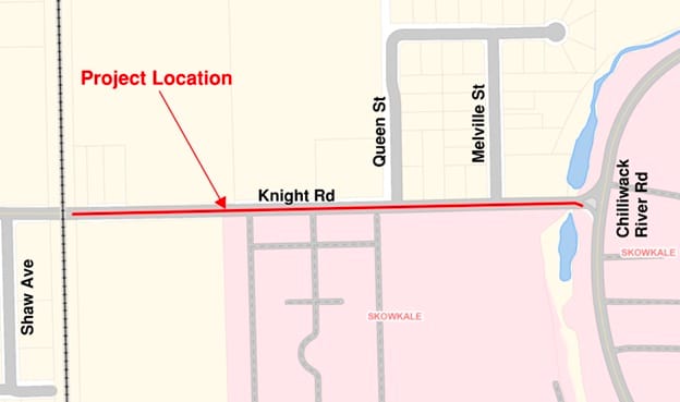
Knight Road at Southern Railway/Valley Rail Trail – Railway and Crosswalk Improvements & Knight Road Multi-Use Pathway
There is a lot going on, coming, and already completed on Knight Road all the way from Evans to Chilliwack River Road.
If social media is a gauge of anything relevant, one might think the work done between Evans and Topaz Drive was about the worst engineering nightmare in the history of transportation. Of course, that's not true. But many people seem to dislike it nonetheless. It took a long time and drivers are still left with one lane in each direction. What was added, however, was lovely wide bike lanes on both sides that no one uses... yet! Build it and they might come.
East of all that fun and east of Vedder Road on Knight is the railway crossing that was updated with new flashing lights, bells and gates. The rectangular rapid flashing beacon crosswalk there was completed in February.
What else? The planned improvements also include new street lights, and updates to signage and road markings.
Background Information
Transport Canada (2014) and Technical Safety BC (2020) introduced new railway grade crossing standards and regulations. The date for all crossings to be updated to these new standards is January 1, 2028. This project is part of Southern Railway's upgrades. The primary goal of these upgrades is to increase safety at the crossings for all road users.
City of Chilliwack photos, map.
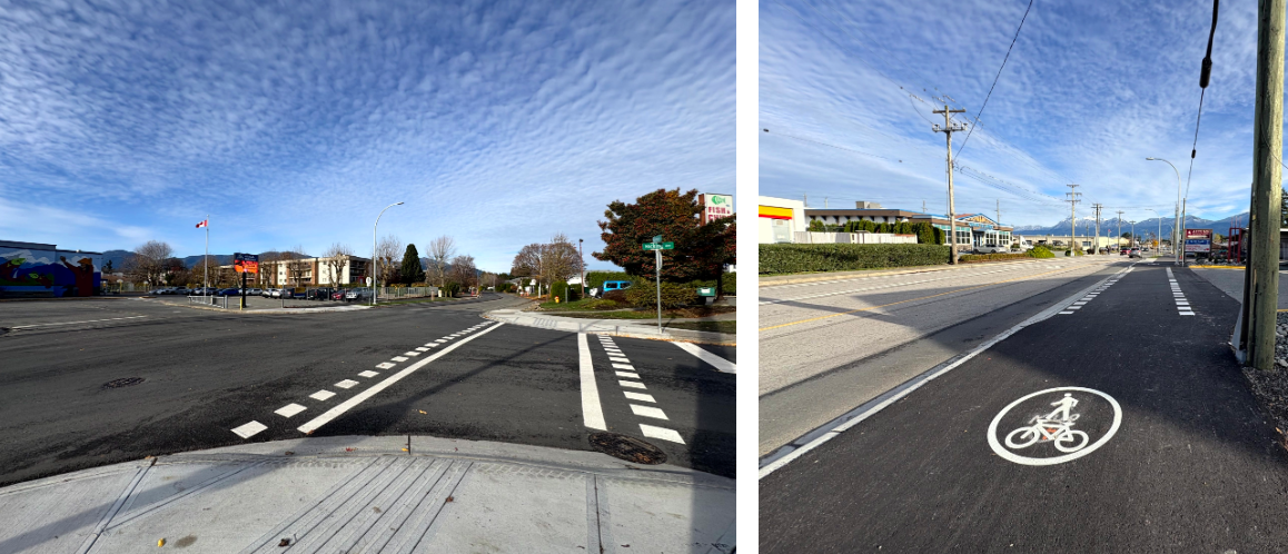
Next up, the Knight Road Multi-Use Pathway
Work began at the end of October 2025 on the multi-use pathway on the stretch of Knight east of the rail line to Chilliwack River Road with full completion expected by the end of March 2026, a date that has gone past. It's alllmost done.
The multi-use pathway is now paved and protected by a grassed and treelined boulevard, and is ready to use.
Project details
The Knight Road multi-use pathway project was tendered under the 2025 Active Transportation Upgrades. The pathway is on the south side of the road. This new pathway connectes the Valley Rail Trail to Chilliwack River Road to create a safe section of road for active transportation users, including cyclists and pedestrians.
This project includes the following works:
• Full-depth asphalt removal.
• Construction of a three-metre-wide multi-use asphalt pathway.
• Creation of a grassed and tree-lined boulevard between the roadway and the multi-use pathway.
• Installation of barrier and roll over concrete curb and driveway letdowns as required.
• Installation of storm drainage works, including catch basins, lawn basins, storm service tie-ins, rock pit, infiltration and swales.
• New road markings and signage changes.
• Landscaping and property restorations.
-30-
Want to support independent journalism?
Consider becoming a paid subscriber or make a one-time donation so I can continue this work.
Paul J. Henderson
pauljhenderson@gmail.com
facebook.com/PaulJHendersonJournalist
instagram.com/wordsarehard_pjh
x.com/PeeJayAitch
wordsarehard-pjh.bsky.social